.

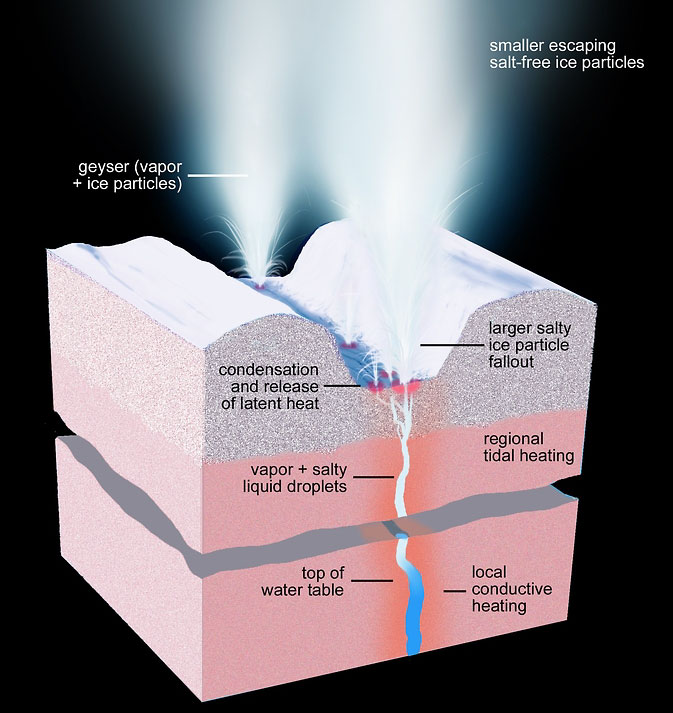
This artist's rendering shows a cross-section of the ice shell immediately beneath one of Enceladus' geyser-active fractures, illustrating the physical and thermal structure and the processes ongoing below and at the surface.
Image Credit: NASA/JPL-Caltech/Space Science Institute
.
Scientists using mission data from NASA’s Cassini spacecraft have identified 101 distinct geysers erupting on Saturn’s icy moon Enceladus. Their analysis suggests it is possible for liquid water to reach from the moon’s underground sea all the way to its surface.
These findings, and clues to what powers the geyser eruptions, are presented in two articles published in the current online edition of the Astronomical Journal.
Over a period of almost seven years, Cassini’s cameras surveyed the south polar terrain of the small moon, a unique geological basin renowned for its four prominent "tiger stripe” fractures and the geysers of tiny icy particles and water vapor first sighted there nearly 10 years ago. The result of the survey is a map of 101 geysers, each erupting from one of the tiger stripe fractures, and the discovery that individual geysers are coincident with small hot spots. These relationships pointed the way to the geysers’ origin.
After the first sighting of the geysers in 2005, scientists suspected repeated flexing of Enceladus by Saturn’s tides as the moon orbits the planet had something to do with their behavior. One suggestion included the back-and-forth rubbing of opposing walls of the fractures generating frictional heat that turned ice into geyser-forming vapor and liquid.
Alternate views held that the opening and closing of the fractures allowed water vapor from below to reach the surface. Before this new study, it was not clear which process was the dominating influence. Nor was it certain whether excess heat emitted by Enceladus was everywhere correlated with geyser activity.
To determine the surface locations of the geysers, researchers employed the same process of triangulation used historically to survey geological features on Earth, such as mountains. When the researchers compared the geysers’ locations with low-resolution maps of thermal emission, it became apparent the greatest geyser activity coincided with the greatest thermal radiation. Comparisons between the geysers and tidal stresses revealed similar connections. However, these correlations alone were insufficient to answer the question, “What produces what?”
The answer to this mystery came from comparison of the survey results with high-resolution data collected in 2010 by Cassini’s heat-sensing instruments. Individual geysers were found to coincide with small-scale hot spots, only a few dozen feet (or tens of meters) across, which were too small to be produced by frictional heating, but the right size to be the result of condensation of vapor on the near-surface walls of the fractures. This immediately implicated the hot spots as the signature of the geysering process.
“Once we had these results in hand we knew right away heat was not causing the geysers, but vice versa,” said Carolyn Porco, leader of the Cassini imaging team from the Space Science Institute in Boulder, Colorado, and lead author of the first paper. “It also told us the geysers are not a near-surface phenomenon, but have much deeper roots.”
Thanks to recent analysis of Cassini gravity data, the researchers concluded the only plausible source of the material forming the geysers is the sea now known to exist beneath the ice shell. They also found that narrow pathways through the ice shell can remain open from the sea all the way to the surface, if filled with liquid water.
In the companion paper, the authors report the brightness of the plume formed by all the geysers, as seen with Cassini’s high resolution cameras, changes periodically as Enceladus orbits Saturn. Armed with the conclusion the opening and closing of the fractures modulates the venting, the authors compared the observations with the expected venting schedule due to tides.
They found the simplest model of tidal flexing provides a good match for the brightness variations Cassini observes, but it does not predict the time when the plume begins to brighten. Some other important effect is present and the authors considered several in the course of their work.
The Cassini-Huygens mission is a cooperative project of NASA, the European Space Agency and the Italian Space Agency. The Jet Propulsion Laboratory (JPL) in Pasadena, California, manages the mission for NASA's Science Mission Directorate in Washington. The Cassini orbiter and its two onboard cameras were designed, developed and assembled at JPL. The imaging team consists of scientists from the United States, England, France and Germany. The imaging team is based at the Space Science Institute.
.

This artist's rendering shows a regional cross-section of the ice shell underlying Enceladus' south polar terrain, illustrating our current knowledge of the physical and thermal structure and processes ongoing below and at the surface. Narrow cracks extend upward from the sub-surface sea all the way to the surface, through both ductile and brittle layers of the ice shell. Liquid water under pressure fills the cracks, keeping them open even through the ductile layer and providing a conduit for vapor and sea water to reach the near-surface. Other processes, such as volatile exsolution of gases, can drive vapor and water droplets all the way to the surface, forming geysers and condensing close to the surface, depositing latent heat. This heat is observed by Cassini's long-wavelength infrared instruments as the small-scale hot spots (dozens of feet, or tens of meters in size) surrounding each geyser (see PIA17189).
The subsurface regions immediately surrounding the sea and the cracks bearing water and vapor are expected to be warm. Regional heating from tidal flexing is also expected to be present, but is so far undetected.
The ice shell lying above the sea is comparable in thickness to the distance between the tiger stripe fractures, suggesting that the latter might be cracks formed in the past when tensional stresses across the region were stronger.
The surface area of the south polar terrain is approximately that of Scotland.
.

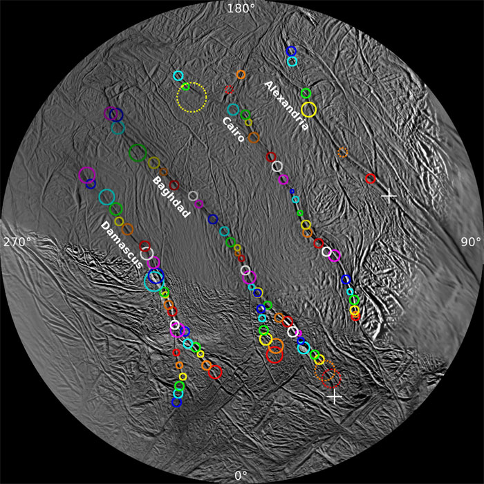
On this polar stereographic map of Enceladus' south polar terrain, all 100 geysers have been plotted whose source locations have been determined in Cassini's imaging survey of the moon's geyser basin. The uncertainty attached to each location is given by the size of the surrounding circle.
Five sources are indicated by dashed circles. Each of these jets appeared only in images taken very close together in time; in other words, the source locations have been confidently determined, but their tilts are uncertain.
The two crosses -- one on Alexandria and one at the end of Baghdad -- indicate two jets. Each was observed in one image only but each was intersected by the shadow of Enceladus, as in PIA17184, allowing a determination of the fracture on which they lie.
This map and the information it contains were used to compare geysering activity with enhanced thermal emission observed by Cassini's heat-measuring instruments and with the distribution of tidal stresses across the region. Those comparisons yielded the clues needed to ascertain the mechanisms underlying the geysering process.
.

This dramatic view looks across the region of Enceladus' geyser basin and down on the ends of the Baghdad and Damascus fractures that face Saturn. The image, which looks approximately in the direction of Saturn, was taken from a more elevated viewpoint than other Cassini survey images of this area of the moon's south pole.
The geysering segments of the fractures seen here are among the most active and warmest in the whole region. As seen from the spacecraft from an elevation angle of 25 degrees south, the jets are projected against the bright surface as opposed to black sky. Consequently, despite the pronounced activity, the jets appear fuzzy, or indistinct, in this image and their tilts are consequently not measurable. Though their source locations are clearly seen, this image was not used in the process of triangulation, but instead it was used to confirm source locations determined from triangulation using other images.
The image was taken with Cassini's narrow-angle camera through the clear filter on August 13, 2010, with an image scale about 230 feet (70 meters) per pixel and a sun-Enceladus-spacecraft, or phase, angle of about 151 degrees.
.

This Cassini narrow-angle camera image -- one of those acquired in the survey conducted by the Cassini imaging science team of the geyser basin at the south pole of Enceladus -- was taken as Cassini was looking across the moon's south pole. At the time, the spacecraft was essentially in the moon's equatorial plane. The image scale is 1280 feet (390 meters) per pixel and the sun-Enceladus-spacecraft, or phase, angle is 162.5 degrees.
The image was taken through the clear filter of the narrow angle camera on November 30, 2010, 1.4 years after southern autumnal equinox. The shadow of the body of Enceladus on the lower portions of the jets is clearly seen.
In an annotated version of the image, the colored lines represent the projection of Enceladus' shadow on a plane normal to the branch of the Cairo fracture (yellow line), normal to the Baghdad fracture (blue line) and normal to the Damascus fracture (pink line).
.

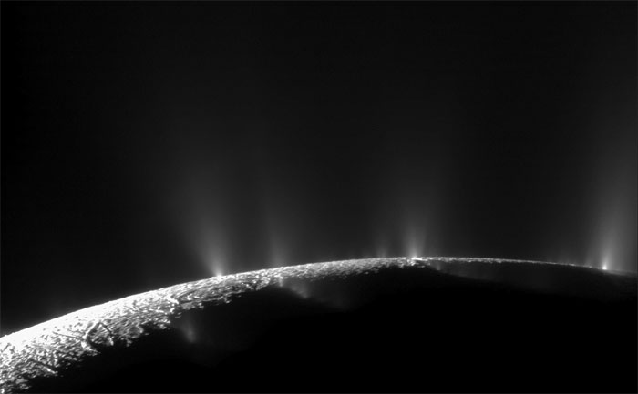
Dramatic plumes, both large and small, spray water ice and vapor from many locations along the famed "tiger stripes" near the south pole of Saturn's moon Enceladus. The tiger stripes are four prominent, approximately 84-mile- (135-kilometer-) long fractures that cross the moon's south polar terrain.
This two-image mosaic is one of the highest resolution views acquired by Cassini during its imaging survey of the geyser basin capping the southern hemisphere of Saturn's moon Enceladus. It clearly shows the curvilinear arrangement of geysers, erupting from the fractures. .From left to right, the fractures are Alexandria, Cairo, Baghdad, and Damascus.
As a result of this survey, 101 geysers were discovered: 100 have been located on one of the tiger stripes (PIA17188) , and the three-dimensional configurations of 98 of these geysers have also been determined (PIA17186). The source location of the remaining geyser could not be definitively established. These results, together with those of other Cassini instruments, now strongly suggest that the geysers have their origins in the sea known to exist beneath the ice underlying the south polar terrain (PIA17190).
,

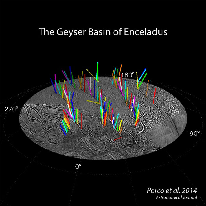
This graphic shows a 3-D model of 98 geysers whose source locations and tilts were found in a Cassini imaging survey of Enceladus' south polar terrain by the method of triangulation. While some jets are strongly tilted, it is clear the jets on average lie in four distinct "planes" that are normal to the surface at their source location.
Dotted vectors indicate five jets whose sources were determined from images acquired too closely in time to determine tilts accurately. Consequently their 3-D configuration has a large uncertainty associated with it.
Quelle: NASA
5008 Views
