9.12.2024

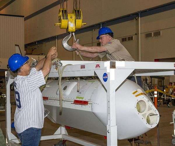
The Uninhabited Aerial Vehicle Synthetic Aperture Radar, UAVSAR, is prepared for installation onto NASA's C-20A aircraft. THE UAVSAR uses a technique called interferometry to detect and measure very subtle deformations in the Earth's surface, and the pod is specially designed to be interoperable with unmanned aircraft in the future. It will gather data from Gabon, Africa in September of 2023. NASA/Steve Freeman
In an era of increasing extreme weather events and natural disasters, NASA's C-20A aircraft is playing a vital role in collecting data to improve disaster response and prediction efforts. Operated from NASA's Armstrong Flight Research Center in California, this modified Gulfstream III business jet supports various Earth science research missions.
In October, the C-20A was deployed to study the aftermath of Hurricane Milton, a Category 3 storm with 120 mph winds that caused significant flooding and tornadoes along Florida's coastline. Outfitted with the Uninhabited Aerial Vehicle Synthetic Aperture Radar (UAVSAR), the aircraft gathered detailed data on flood-affected areas.
"Our team focused specifically on inland river flooding near dense populations, collecting data that could help inform disaster response and preparation in the future," said Starr Ginn, C-20A aircraft project manager. "By all indications, this rapid response to support Hurricane Milton recovery efforts was a successful coordination of efforts by science and aircraft teams."
Developed by NASA's Jet Propulsion Laboratory, the UAVSAR uses interferometry to measure subtle surface changes before and after extreme events. It can capture detailed terrain changes with higher precision and frequency than satellite instruments, making it an indispensable tool for disaster science. "We can design overlapping flights in three or more directions to detect more textures and motions on the Earth's surface," Ginn explained.
The C-20A also supported research on the Portuguese Bend landslide in California's Rancho Palos Verdes. The landslide, reactivated in 1956, has been moving at increasing rates during dry seasons. UAVSAR provided high-resolution data to better understand its dynamics. "The high-resolution capability of UAVSAR is ideal for landslides since they have relatively small features," Ginn said.
Wildfire research was another focus area for the C-20A. The aircraft participated in the Fire and Smoke Model Evaluation Experiment (FASMEE), a multi-agency initiative led by the U.S. Forest Service. This study aimed to analyze fire behavior and smoke production.
"The airborne perspective allows FASMEE researchers to better understand fire behavior and smoke production," said Michael Falkowski, program manager for NASA's Applied Sciences Wildland Fire program. The data gathered helps researchers track forest composition, moisture levels, and fire progression.
Jacquelyn Shuman, FireSense project scientist at NASA's Ames Research Center, highlighted the importance of such studies: "We can explore how fire managers can use airborne data to help make decisions about fires."
From hurricanes to landslides to wildfires, NASA's C-20A aircraft continues to provide crucial airborne data to improve scientific understanding and disaster preparedness.
Quelle: SD
