
23.02.2023

VON USA VERÖFFENTLICHT
Foto zeigt China-Ballon kurz vor dem Abschuss
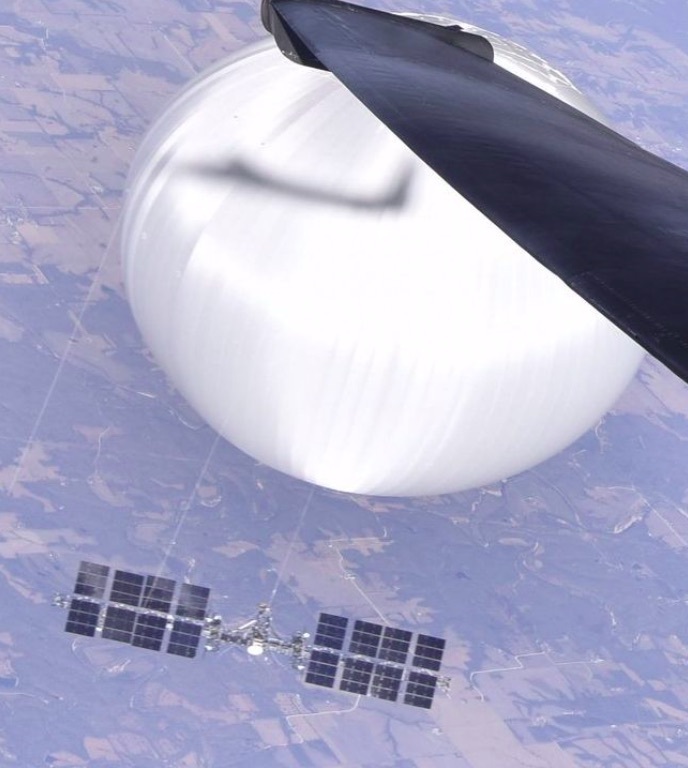
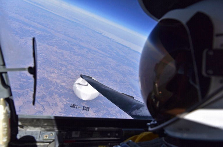
Das Foto ist aus dem Cockpit eines Aufklärungsflugzeugs des US-Militärs aufgenommen worden. Nur einen Tag später schoss das US-Militär den chinesischen Ballon vor der Küste des Bundesstaats South Carolina über dem Atlantik ab.
Bergung des Ballons bereits abgeschlossen
Die Bergung des Ballons war bereits Ende vergangener Woche abgeschlossen worden. Die Trümmerteile werden nun vom Spionageabwehrbüro der Bundespolizei FBI ausgewertet. „Der größte Teil des Ballons, einschließlich der Ladung, wurde geborgen“, sagte Pentagon-Sprecherin Sabrina Singh am Mittwoch. Weitere Einzelheiten zur Auswertung der Trümmer wollte sie nicht nennen und verwies an das FBI.
")
NORAD Conducted Multiple Air Defense Exercises After UFOs Shot Down
NORAD führte mehrere Luftverteidigungsübungen durch, nachdem UFOs abgeschossen wurden

NORAD conducted multiple air defense exercises after three UFOs were shot down. However, NORAD does routinely conduct exercises, so it’s unclear if this was unusual or not. Here’s a look at the timing of NORAD’s exercises compared to when the UFOs were shot down.
NORAD führte mehrere Luftverteidigungsübungen durch, nachdem drei UFOs abgeschossen worden waren. NORAD führt jedoch routinemäßig Übungen durch, daher ist unklar, ob dies ungewöhnlich war oder nicht. Hier ist ein Blick auf den Zeitpunkt der Übungen von NORAD im Vergleich zum Abschuss der UFOs.
NORAD’s Air Defense Exercises Began Shortly After the UFOs Were Shot Down
NORAD began a series of air defense exercises shortly after the three UFOs were shot down. The balloon that officials knew was a Chinese spy balloon was shot down on February 4, AP reported, followed by the Alaskan UFO, the Candian Yukon UFO on February 11, and the Lake Huron UFO on February 12.
The first air defense exercises then began. On February 14, the Alaskan Region of NORAD conducted a “routine intercept of Russian aircraft entering Air Defense Identification Zone” and noted in a tweet that this was “in no way related to recent NORAD and U.S. Northern Command operations associated with airborne objects over North America during the last two weeks.”
Die Luftverteidigungsübungen von NORAD begannen kurz nachdem die UFOs abgeschossen wurden
NORAD begann kurz nach dem Abschuss der drei UFOs mit einer Reihe von Luftverteidigungsübungen. Der Ballon, von dem die Beamten wussten, dass es sich um einen chinesischen Spionageballon handelte, wurde am 4. Februar abgeschossen, berichtete AP, gefolgt vom UFO von Alaska, dem UFO von Candian Yukon am 11. Februar und dem UFO von Lake Huron am 12. Februar.
Anschließend begannen die ersten Luftverteidigungsübungen. Am 14. Februar führte die alaskische Region von NORAD ein „routinemäßiges Abfangen russischer Flugzeuge, die in die Luftverteidigungs-Identifikationszone einflogen“ durch und stellte in einem Tweet fest, dass dies „in keiner Weise mit den jüngsten Operationen von NORAD und dem US-Nordkommando im Zusammenhang mit Luftobjekten über dem Norden Amerika während der letzten zwei Wochen zusammenhängt .“

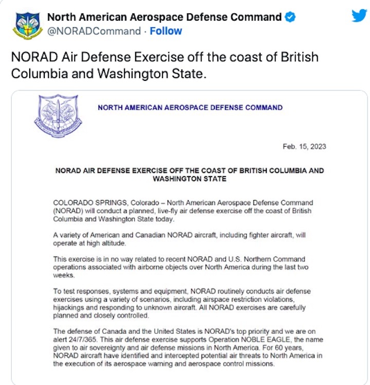
Then on February 15, NORAD hosted a “planned, life-fly air defense exercise off the coast of British Columbia and Washington State.” This was noted to be “in no way related to recent NORAD and U.S. Northern Command operations associated with airborne objects over North America during the last two weeks.”
Dann, am 15. Februar, veranstaltete NORAD eine „geplante lebensfliegende Luftverteidigungsübung vor der Küste von British Columbia und dem Staat Washington“. Es wurde festgestellt, dass dies „in keiner Weise mit den jüngsten Operationen von NORAD und dem US-Nordkommando im Zusammenhang mit luftgestützten Objekten über Nordamerika während der letzten zwei Wochen zusammenhängt“.
Then again on February 15, NORAD hosted another air defense exercise — a “live, fly-air defense exercise” — this time off the coast of North Carolina. This was also noted to be “in no way related to recent NORAD and U.S. Northern Command operations associated with airborne objects over North America during the last two weeks.”
Dann wieder, am 15. Februar, veranstaltete NORAD eine weitere Luftverteidigungsübung – eine „Live-Luftverteidigungsübung“ – diesmal vor der Küste von North Carolina. Es wurde auch festgestellt, dass dies „in keiner Weise mit den jüngsten Operationen von NORAD und dem US-Nordkommando im Zusammenhang mit luftgestützten Objekten über Nordamerika während der letzten zwei Wochen zusammenhängt“.

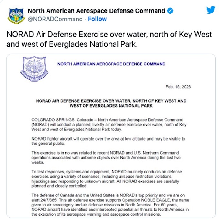
Then, again on February 15, NORAD announced an air defense exercise over Key West and west of Everglades National Park, also not related to recent airborne objects.
Dann, wieder am 15. Februar, kündigte NORAD eine Luftverteidigungsübung über Key West und westlich des Everglades-Nationalparks an, die ebenfalls nichts mit kürzlich in der Luft befindlichen Objekten zu tun hatte.
NORAD does routinely host air defense exercises. We know that in January 2023 and throughout 2022 they hosted operations called Noble Defender, which were training operations in the Arctic and in other locations. In August 2022, they tweted about air defense exercises in central California. A look back at their past tweets does indicate that they frequently do air defense exercises in Washington D.C., but it’s unclear how often the other locations like Washington State occur.
NORAD veranstaltet regelmäßig Luftverteidigungsübungen. Wir wissen, dass sie im Januar 2023 und im gesamten Jahr 2022 Operationen namens Noble Defender veranstalteten, bei denen es sich um Trainingsoperationen in der Arktis und an anderen Orten handelte. Im August 2022 twitterten sie über Luftverteidigungsübungen in Zentralkalifornien. Ein Rückblick auf ihre vergangenen Tweets zeigt zwar, dass sie häufig Luftverteidigungsübungen in Washington D.C. durchführen, aber es ist unklar, wie oft die anderen Standorte wie der Staat Washington vorkommen.
Recap of the 3 Shot-Down UFOs
Zusammenfassung der 3 abgeschossenen UFOs

Photo from NORAD’s Twitter from its Nobel Defender program, unrelated to the UFOs.
Foto von NORADs Twitter aus seinem Nobel Defender-Programm, das nichts mit den UFOs zu tun hat.
Here’s a quick rundown of the three objects that were shot down:
- Alaska: This object was the size of a small car, the Guardian reported. It was smaller and tougher to detect and landed off the coast of Alaska in “difficult terrain” with temperatures in the “minus 40s.” (Gen. Mark Milley via NBC News)
- Canadian Yukon UFO: This one was smaller and tougher to detect (Crenshaw tweet.) It landed in the Canadian Rockies and the Yukon and is “very difficult” to get to. (Gen. Milley via NBC News)
- Lake Huron UFO: This object, shot down near the Canadian border, was octagonal in shape and looked like it might have strings attached, the Guardian reported. It is believed to be the same object originally seen in Montana. Rep. Crenshaw tweeted that this one was larger and easier to pick up by radar, more closely resembling a balloon. According to Milley, this one is probably “a couple 100 feet depth” in Lake Huron and will take time to recover. (Gen. Milley via NBC News)
The searches for debris from all three objects have been called off.
Hier ist ein kurzer Überblick über die drei Objekte, die abgeschossen wurden:
Alaska: Dieses Objekt hatte die Größe eines Kleinwagens, berichtete der Guardian. Es war kleiner und schwieriger zu erkennen und landete vor der Küste Alaskas in „schwierigem Gelände“ mit Temperaturen von „minus 40“. (Gen. Mark Milley über NBC News)
Kanadisches Yukon-UFO: Dieses war kleiner und schwieriger zu entdecken (Crenshaw-Tweet). Es landete in den kanadischen Rocky Mountains und im Yukon und ist „sehr schwer“ zu erreichen. (Gen. Milley über NBC News)
Lake Huron UFO: Dieses Objekt, das in der Nähe der kanadischen Grenze abgeschossen wurde, hatte eine achteckige Form und sah aus, als wären Fäden daran befestigt, berichtete der Guardian. Es wird angenommen, dass es sich um dasselbe Objekt handelt, das ursprünglich in Montana gesehen wurde. Rep. Crenshaw twitterte, dass dieser größer und leichter vom Radar zu erfassen sei und eher einem Ballon ähnele. Laut Milley ist dieser wahrscheinlich „ein paar 100 Fuß tief“ im Lake Huron und wird einige Zeit brauchen, um sich zu erholen. (Gen. Milley über NBC News)
Die Suche nach Trümmern von allen drei Objekten wurde eingestellt.
Quelle: Post Apocalyptic Media
----
Update: 26.02.2023
.
How One Guy’s AI Tracked the Chinese Spy Balloon Across the US
EARLIER THIS MONTH, entrepreneur Corey Jaskolski pulled out a pen and drew his best guess at what the surveillance balloon shot down by a US jet would have looked like from space. Then he fed the sketch and “a gob” of recent satellite images from the area where the balloon was taken down into algorithms developed by his image and video detection startup Synthetatic, and waited.
Within two minutes, he says, the algorithms found the 200-foot-tall balloon off the coast of South Carolina. “I couldn’t believe it,” Jaskolski says. Nor could his wife when he excitedly showed her his results. But when he estimated the altitude of the balloon in the image it was around 57,000 feet—matching the height at which the balloon was spotted by a US spy plane—and social media sightings from 20 minutes before the image was taken appeared to confirm he had found it.
Jaskolski dug in, poring over wind models and social media sightings to feed his software, called RAIC (rapid automatic image categorization), new swathes of satellite data from the company Planet Labs. The tool is designed to make it possible to search large image collections for objects of interest using a single example image.
“We drew a big arc across time and space and started searching that,” Jaskolski says. Having found the balloon once, Synthetiatic’s software could be trained with a real image of the balloon to further guide its search.
Over the next several days, Jaskolski put RAIC to work. The company has since compiled six sightings of the balloon (five confirmed, one still being investigated) on its satellite imagery and has used wind data to estimate how it moved between those points. “We can draw a 1-kilometer-wide track across the whole of the United States and just follow the balloon,” he says. “We have a track from where it entered from Canada, all the way to South Carolina, where it got popped, with six points along that arc.”
Jaskolski’s stratospheric scavenger hunt may have been made possible by smart software, but it also required human expert knowledge. His initial drawing of the craft looked more like a technicolor snowman—stacked red, green, and blue circles. The aim was to mimic the way satellites generally capture different wavelengths of light using separate sensors that aren’t always synced in time, creating multiple disjointed views of objects. And it throws up false positives
![]()
But the ability to map a surveillance balloon’s path with such clarity could be a game changer for national security, says Arthur Holland Michel, senior fellow at the Carnegie Council and author of a book on drones and surveillance. “The combination of AI with satellite imagery is undoubtedly a very powerful technology for surveillance and espionage and counterespionage,” he says.
Holland Michel also points out that satellite imagery and AI have their limitations. The method by which Synthetatic first found the balloon—using a drawing—could result in false positives if the object of interest was something more complex or less publicly documented, such as a tank. “Things often look a bit weird and unfamiliar from above,” he says.
“There’s undoubted potential there,” Holland Michel says, “but it’s easy to think this combination of satellites and AI is an all-seeing capability that will lay everything bare.” It’s useful in certain cases, like the balloon, he says, but likely not all scenarios.
That’s something Jaskolski acknowledges—but he also considers the project an example of how human expertise and grunt work can be elevated by AI. “This human-machine collaboration is my idea of how AI works today,” he says. “And it’s definitely how we build our product.” The tool is currently used for humanitarian purposes, including by the UN World Food Program to find flood victims.
The pursuit of the balloon isn’t over just because Jaskolski has managed to track it across the United States. He says the process is “resource-intensive” because the software isn’t perfect and turns up many potential sightings that have to be whittled down by people. “But we’d like to still continue to track it,” he says. “Whether we go all the way back to China or not, we feel like we solved a technical problem at least. We’d be crazy not to try.”
Quelle: WIRED