.

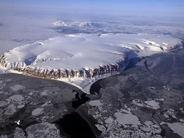
IceBridge Survey Flight Over Saunders Island and Wolstenholme Fjord
This image of Saunders Island and Wolstenholme Fjord with Kap Atholl in the background was taken during an Operation IceBridge survey flight in April, 2013. Sea ice coverage in the fjord ranges from thicker, white ice seen in the background, to thinner grease ice and leads showing open ocean water in the foreground.
In March 2013, NASA's Operation IceBridge scientists began another season of research activity over Arctic ice sheets and sea ice. IceBridge, a six-year NASA mission, is the largest airborne survey of Earth's polar ice ever flown. It will yield an unprecedented three-dimensional view of Arctic and Antarctic ice sheets, ice shelves and sea ice. These flights will provide a yearly, multi-instrument look at the behavior of the rapidly changing features of the Greenland and Antarctic ice.
.
Scientists and engineers with NASA's Operation IceBridge continued their work to gather vital information on Arctic ice with flights into areas not extensively covered in previous campaigns. With one sea ice flight and one ice sheet survey in the books, researchers are heading toward the end of the campaign and the last of the mission's high priority flights.
Greenland's Thule Air Base puts the NASA P-3B in range of large portions of Arctic sea ice, some of which IceBridge flew over on Apr. 22. This mission was a repeat of one from 2012 and aimed at sampling a large region of the Canada Basin between IceBridge survey lines flown out of and on the way back from Fairbanks, Alaska.
This mission also involved coordinating with a satellite that provides data for the Global Fiducials Library (GFL) at the U.S. Geological Survey. GFL is a collaborative effort between various academic institutions and U.S. government agencies that maintains a long-term record of high-resolution imagery of Arctic sea ice. On Apr. 22 and 23 a satellite was to capture images at 10 locations multiple times per day in the area of IceBridge's flight line, and IceBridge's goal was to survey that region on one of those two days. The objective of this collaboration was to see how feasible coordinating observations from multiple sources is and to find out what benefits there are in combining such measurements of Arctic sea ice cover.
Completing the Apr. 22 survey meant that IceBridge planners had two high-priority sea ice mission plans left, a survey farther south in the Canada Basin and a flight over the North Pole, which had been attempted and canceled earlier in the campaign. As is sometimes the case, weather had other plans. Unfavorable weather over the Canada Basin and a lack of suitable CryoSat-2 overpasses in the Arctic Ocean led mission planners to pass on the two sea ice flights and instead choose a flight over the north-central part of the ice sheet on Apr. 23.
The Apr. 23 flight was a new mission designed to fill in a gap in surface elevation and ice thickness coverage in north Greenland. On this survey, the P-3B flew two lines across the Greenland ice sheet, gathering data along the way. Once at the east coast researchers surveyed the centerlines of the Qeqertarsuap, Drachmann and Wordie glaciers. After returning to the west side of Greenland, the P-3B repeated parts of a coast-parallel survey line flown from 2010 to 2012 before returning to Thule Air Base.
Quelle: NASA
